Geospatial Programming Materials
Spatial Data
HTML intro to spatial data LINK
Open Data and Geopandas Basics
HTML of Jupyter Notebook on open data and geopandas basics. LINK
Assignment posted at end of Notebook.
Metadata and Queries for Open Data
HTML of Jupyter Notebook on open data Metadata and Queries. LINK
Assignment posted at end of Notebook.
Links to Sample Maps
Visualizing Spatial Data
Graduated Circles - Frequent Vehicle Tows
Graduated Circles- Distributed Vehicle Tows
Graduated Circles, Classified Fisher-Jenks k=6, Distributed Vehicle Tows
Choropleth - Vehicle Tow Density
Choropleth, Classified Fisher-Jenks k=6, Vehicle Tow Density
Choropleth, Linear Color Mapper - Vehicle Tow Density
Choropleth, Log Color Mapper - Vehicle Tow Density
Visualizing Spatial Data Spring 2021
Graduated Circles - Frequent Vehicle Tows
Graduated Circles- Distributed Vehicle Tows
Graduated Circles, Classified Fisher-Jenks k=6, Distributed Vehicle Tows
Choropleth - Vehicle Tow Density Lear and Log Cmaps
Choropleth, Classified Fisher-Jenks, Vehicle Tow Density
Predominance Map of CDC Health Outcomes by County
Maps from Visualization Assignment
Graduated Circles- Distributed by Borough - Residential Complaints
Graduated Circles- Distributed by Borough - Commercial Complaints
Choropleth- Distributed by Borough - Residential Complaints / Sq. Ki.
Choropleth- Distributed by Borough - Commercial Complaints / Sq. Ki.
Spatial Data Processing
Buffalo Residential Properties - Tax Assessment Roll 2019-2020
Fire Hydrants near Elementary Schools
Buffalo Potential Road Bridges (Overpasses)
Buffalo Road/Rail Bridges (Overpasses), at-grade, and Underpasses
Black or African American Population Near Elementary Schools
Nearest Neighbor Fire Risk Assessment
This map shows assigned fire risk for a random sample (33%) of residential tax properties instead of the entire dataset.
Spatial Processing Assignment Maps
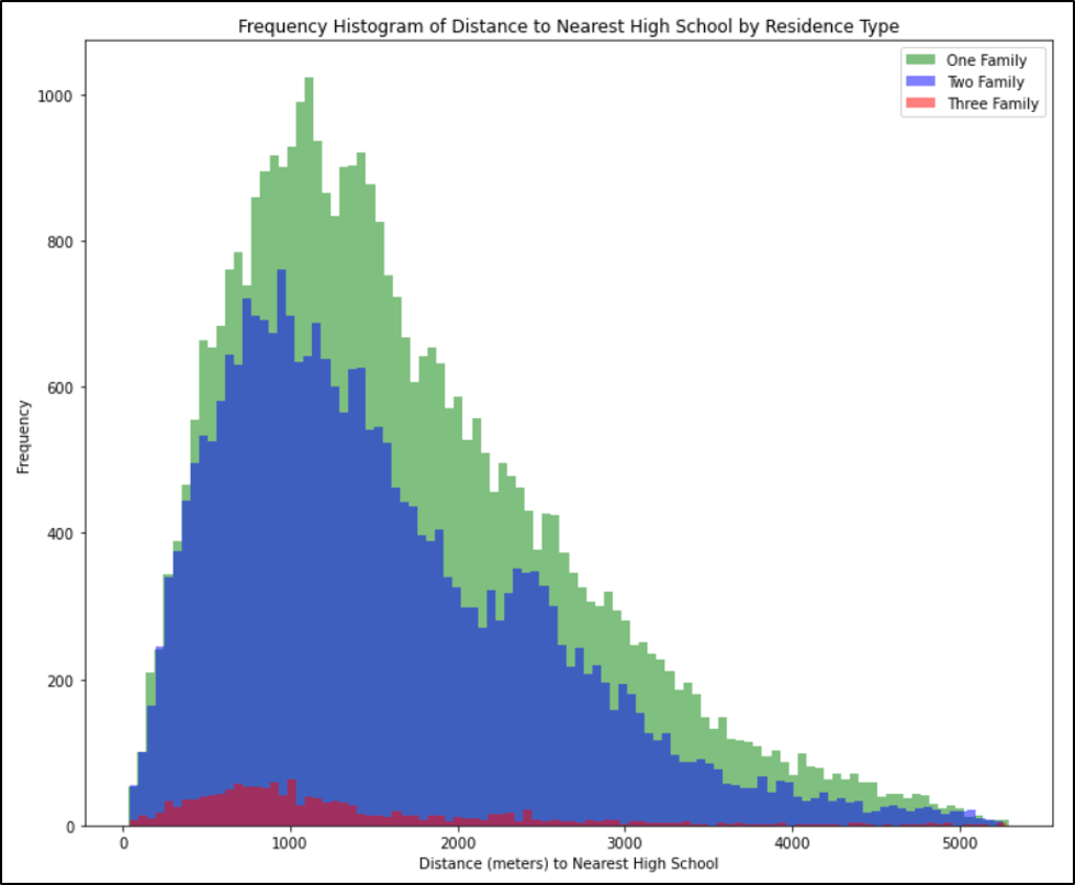
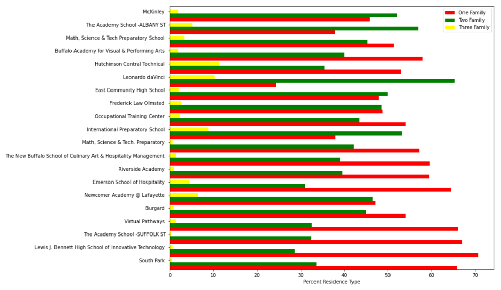
Problem 1 - Closest high school to Residences
High Schools from Buffalo Public Schools 2019-2020 dataset
Unique Public High School Locations in Buffalo
Residences by Type Near High School Locations
Closest Residences to High School Locations
Spatial Autocorrelation (Summer 2020) Maps
COVID -19 Confirmed Cases - Hot and Cold Spots on Apr 15, May 15, and Jun 15, 2020